Since the inception of the Cellular Market Areas in 1982, the Federal Communication Commission has assigned area based radio licenses. Some select areas are listed below with supporting information contained under each heading. Please visit the Geographic Licensing Schemes web page for additional area/auction maps.
Included in this file are the 2017 county-equivalent areas that the FCC licenses on a regional basis. These areas include, in addition to the 50 States, the District of Columbia, Puerto Rico, American Samoa, Guam, the Northern Mariana Islands, and the United States Virgin Islands. We define 2017 counties using the United States Census Bureau’s data reflecting county legal boundaries and names valid through January 1, 2017. To determine the counties, the Wireless Bureau downloaded a shapefile from the Census Bureau entitled County and Equivalent Entity National Shapefile (Current) Counties. Equivalent entities are primary legal divisions of states. In most states, these entities are termed “counties.”
- FCC County 2000 Data 6/17/02
- Get more information 6/17/02
- For areas defined prior to the year 2000 the county-equivalent entities are as defined in the Federal Information Processing Standards Publication 6-4, 1990 August 31.
The Partial Economic Areas, which were established in the Incentive Auction Report and Order, divide EAs into 416 service areas. Cite: Wireless Telecommunications Bureau Provides Details About Partial Economic Areas, GN Docket No. 12-268, Public Notice, DA 14-759 (rel. June 2, 2014).
- List of Partial Economic Areas with Corresponding Economic Areas: Acrobat
- List of Counties with Corresponding Partial Economic Area: Acrobat
- Map of the Partial Economic Areas: Acrobat
- Data
Original CEA definitions defined by the Department of Commerce, Bureau of Economic Analysis.
- CEA Readme File 5/07/02
- CEA DATA 5/07/02
- See more (Geographic Licensing Schemes)
![]()
The Cellular Market Areas (CMAs) were created from the Metropolitan Statistical Areas (MSAs) defined by the Office of Management and Budget (1-305), the Gulf of Mexico (306), and Rural Service Areas (RSAs) established by the FCC which do not cross state borders (307-734). These RSAs include parts of Puerto Rico not already in an MSA (723-729), U.S. Virgin Islands (730-731), Guam (732), American Samoa (733), and Northern Mariana Islands (734)
Cite: Cellular Market Areas listed by the Federal Communications Commission, DA 92-109 (January 24, 1992), 7 FCC Rcd 742 (1992).
- Names
- County List
- Map (Adobe PDF)
- Data (MapInfo Interchange Format and MapInfo Native Table Format)
- See more (Geographic Licensing Schemes)
![]()
The Basic Trading Areas (BTAs) are based on the Rand McNally 1992 Commercial Atlas & Marketing Guide, 123rd Edition, at pages 38-39, with the following additions: American Samoa (492), Guam (490), Northern Mariana Islands (493), San Juan, Puerto Rico (488), Mayagüez/Aguadilla-Ponce, Puerto Rico (489), and the United States Virgin Islands (491).
Cite: Basic Trading Areas delineated by the Rand McNally 1992 Commercial Atlas & Marketing Guide, 123rd Edition, at pages 38-39; extended and revised by the Federal Communications Commission, 59 FR 46195 (September 7, 1994)
- Names
- County List
- Map (Adobe PDF)
- Data (MapInfo Interchange Format and MapInfo Native Table Format)
- See more (Geographic Licensing Schemes)
![]()
The Major Trading Areas (MTAs) are based on the Rand McNally 1992 Commercial Atlas & Marketing Guide, 123rd Edition, at pages 38-39, with the following exceptions and additions:
- Alaska (49) is separated from the Seattle MTA and is to be licensed separately.
- Guam and the Northern Mariana Islands (50) are to be licensed as a single MTA-like area.
- Puerto Rico and the United States Virgin Islands (25) are to be licensed as a single MTA-like area.
- American Samoa (51) is to be licensed as a single MTA-like area.
Cite: Major Trading Areas delineated by the Rand McNally 1992 Commercial Atlas & Marketing Guide, 123rd Edition, at pages 38-39, extended and excepted by the Federal Communications Commission, 59 FR 14115 (March 25, 1994)
- Names
- County List
- Map (Adobe PDF)
- Data (MapInfo Interchange Format and MapInfo Native Table Format)
- See more (Geographic Licensing Schemes)
![]()
The Regional Narrowband PCS service areas, which were created by Commission staff, are an aggregation of MTAs into 5 regions.
Cite: Regional Narrowband PCS Areas delineated by the Federal Communications Commission, 59 FR 14115 (March 25, 1994)
- Names
- County List
- Map (Adobe PDF)
- Data (MapInfo Interchange Format and MapInfo Native Table Format)
- See more (Geographic Licensing Schemes)
![]()
The Economic Area service areas are based on the Economic Areas delineated by the Regional Economic Analysis Division, Bureau of Economic Analysis, U.S. Department of Commerce February 1995 (1-172), with the following additions: Guam and the Northern Mariana Islands (173), Puerto Rico and the U.S. Virgin Islands (174), and American Samoa (175). The Commission has also designated the Gulf of Mexico (176) as an additional Economic Area. However, GWCS, 800 MHz SMR, 220 MHz, and 39 GHz services currently do not implement the Gulf of Mexico (176) as a separate license area.
Cite: Economic Areas delineated by the Regional Economic Analysis Division, Bureau of Economic Analysis, U.S. Department of Commerce February 1995 and extended by the Federal Communications Commission, 62 FR 9636 (March 3, 1997).
Alternate Cite: Economic Areas delineated by the Regional Economic Analysis Division, Bureau of Economic Analysis, U.S. Department of Commerce February 1995 and extended by the Federal Communications Commission, 62 FR 9636 (March 3, 1997) excluding the Gulf of Mexico.
- Names
- County List
- Map (Adobe PDF)
- Data (MapInfo Interchange Format and MapInfo Native Table Format)
- Services:
- General Wireless Communications Service (GWCS) - 47 CFR § 26.102 (4660-4685 MHz: Channel Blocks A-E)
- Specialized Mobile Radio (SMR) 800 MHz - 47 CFR § 90.681 & 90.903 (806-821/851-866 MHz: Spectrum Blocks A-C)
- 220 MHz - 47 CFR § 90.761 (220-222 MHz: Channel Assignments A-E)
- Location and Monitoring Service (LMS) - 47 CFR § 90.7 (3 Spectrum Blocks (1) 904.000-909.750 MHz and 927.750-928.000 MHz; (2) 919.750-921.750 MHz and 927.500-927.750 MHz; and (3) 921.750-927.250 MHz and 927.250-927.500 MHz)
- 38.6-40.0 GHz Band (39 GHz) - 47 CFR § 101.64 (38.6-40.0 GHz: Channels 1-14 with paired blocks A-B) (Change see FCC 99-179 July 14, 1999 News Release | MO&O)
![]()
The Major Economic Areas which were created by Commission staff are an aggregation of BEAs into 52 regions, including the Gulf of Mexico (52).
Cite: Major Economic Areas delineated by the Federal Communications Commission, 62 FR 9636 (March 3, 1997).
- Names
- County List
- Map (Adobe PDF)
- Data (MapInfo Interchange Format and MapInfo Native Table Format)
- See more (Geographic Licensing Schemes)
![]()
The Regional Economic Areas also known as the Regional Economic Area Groupings for WCS which were created by Commission staff are an aggregation of MEAs into 12 regions.
Cite: Regional Economic Areas delineated by the Federal Communications Commission, 62 FR 9636 (March 3, 1997).
- Names
- County List
- Map (Adobe PDF)
- Data (MapInfo Interchange Format and MapInfo Native Table Format)
![]()
The Economic Area Groupings also know as Regional Economic Area Groupings for 220 MHz which were created by Commission staff are an aggregation of BEAs into 6 regions excluding the Gulf of Mexico.
Cite: Economic Area Groupings delineated by the Federal Communications Commission, 62 FR 15978 (April 3, 1997)
Cite: Economic Area Groupings delineated by the Federal Communications Commission, 62 FR 15978 (April 3, 1997) extended with the Gulf of Mexico, 65 FR 3139 (January 20, 2000)
- Names
- County List
- Map (Adobe PDF)
- Data (MapInfo Interchange Format and MapInfo Native Table Format)
- See more (Geographic Licensing Schemes)
![]()
The VHF Public Coast Station Areas (VPCs) which were created by Commission staff are an aggregation of BEAs into 42 areas, including the Gulf of Mexico (4).
VPCs 1-9 are called Maritime VPCs and VPCs 10-42 are called Inland Areas. The Maritime VPCs are an aggregation of one or more BEAs and the Inland Areas are defined as exactly one BEA.
Cite: VHF Public Coast Station Areas delineated by the Federal Communications Commission, 63 FR 40059 (July 27, 1998).
- Names
- County List
- Map (Adobe PDF)
- Data (MapInfo Interchange Format and MapInfo Native Table Format)
![]()
The Public Safety Planning Regions were established in the National Public Safety Planning Advisory Committee (NPSPAC) Proceeding in 1987 [see General Docket No. 87-112, Memorandum Opinion and Order, FCC 88-132, 3 FCC Rcd 2113 (1988), 53 FR 11849 (April 11, 1988)].
Cite: Public Safety Planning Regions developed by the National Public Safety Planning Advisory Committee (NPSPAC) and revised by the Federal Communications Commission, 53 FR 11849 (April 11, 1988)
- Names
- County List
- Map (Adobe PDF)
- Data (MapInfo Interchange Format and MapInfo Native Table Format)
![]()
Television Market Areas (TMAs) are the areas for the cable must-carry/retransmission consent election. (47 CFR § 76.55)
Note: Television Market Areas are not static and change every three years. When referencing this particular area designation always include a year.
- Definition of the Television Market Areas for the 1996 election
- CONUS: Area of Dominant Influence (ADI) as determined by Arbitron and published in the Arbitron 1991–1992 Television ADI Market Guide.
- AK & HI: Designated Market Area (DMA) as determined by Nielsen Media Research and published in the Nielsen 1991–1992 DMA Market and Demographic Rank Report.
- PR, VI & GU: Each is considered a single Television Market Area
- Definition of the Television Market Areas for the 1999 election (effective January 1, 2000)
- 1997-1998 DMA Market and Demographic Rank Report, by Nielsen Media Research
- Definition of the Television Market Areas for the future 2002 election
- 2000-2001 DMA Market and Demographic Rank Report, by Nielsen Media Research
Currently no mapping data is available.
- Service:
- Cable Television Service 47 CFR 76 Subpart D
- Children's Television Programming Report (Form 398)
![]()
Emergency Alert System Local Areas (EAS) are geographical areas of contiguous communities or counties (currently only county-equivalents) that may include more than one state. (47 CFR § 11.21)
Note: Emergency Alert System Local Areas are not static and are apt to change at the discretion of the states and local communities.
Currently no mapping data is available.
- Service:
- Emergency Alert System 47 CFR § 11.21
![]()
In General Docket 79-188 the FCC created the Digital Electronic Message Service (DEMS). This service was to be licensed on a market basis and it was decided to use the 323 SMSAs that resulted from the 1980 Census. SMSAs are unique in that they are not continuous across the nation. Also, they aggregate minor civil divisions (towns and cites) as opposed to county-equivalents in New England.
Cite: Standard Metropolitan Statistical Areas defined by Office of Management and Budget, June 30, 1981.
- Names
- County and MCD list
- Map (Adobe PDF)
- Data (MapInfo Interchange Format and MapInfo Native Table Format)
- Service
- Original* Digital Electronic Message Service (DEMS) - 18 GHz and 24 GHz
* The modern DEMS service areas will be decided in WT Docket 99-327. In the recent NPRM, FCC 99-333 ( News Release | Notice ), the FCC proposed to use Economic Areas (BEA).
![]()
The 50 States, the District of Columbia, American Samoa, Guam, Northern Mariana Islands, Puerto Rico, and United States Virgin Islands, (NWA255)
Cite: Nationwide Area delineated by the Federal Communications Commission, 59 FR 14115 (March 25, 1994)
- Service:
- Narrowband PCS - 47 CFR § 24.102 (901-902, 930-931 MHz, 940-941 MHz: Channels 1-11)
![]()
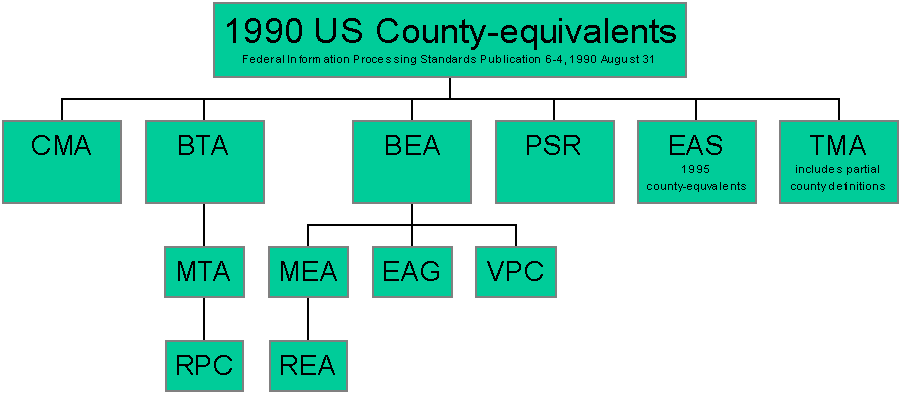
1990 US County-equivalents (for reference only)
Included in this file are only those county-equivalent areas that the FCC licenses on a regional basis. These areas include, in addition to the 50 States, the District of Columbia, Puerto Rico, American Samoa, Guam, the Northern Mariana Islands, and the United States Virgin Islands. The Gulf of Mexico is also included as a county-equivalent-like area.
![]()
1990 US State-equivalents (for reference only)
Included in this file are only those state-equivalent areas that the FCC licenses on a regional basis. These areas include, in addition to the 50 States, the District of Columbia, Puerto Rico, American Samoa, Guam, the Northern Mariana Islands, and the United States Virgin Islands.
![]()
Cross Reference Tables (for reference only)
- 1990 US County-equivalents to areas above
- 1995 US County-equivalents to areas above (see note below)
- 1999 US County-equivalents to areas above (see note below)
- Basic Trading Areas (BTAs) to MTAs, RPCs.
- Economic Areas (BEAs) to MEAs, REAs, EAGs, VPCs
- FCC Area Relationship Chart ( GIF Image | PowerPoint 97 )
![]()